
Climate data can be downloaded as multilayer raster GeoTIFF (.tif) files. Projection is WGS 84 / UTM zone 38 (epsg: 32738) and resolution is 1km on an extent covering Madagascar. Data type is INT16 (16-bit integer value) with -32768 set as no value. Each raster has 70 layers (named from raster.1 to raster.70) and an approximate size of 25 Mo. Layers describe the following climate variables:
| Layers | Climate variable |
|---|---|
| 1-12 | Monthly minimum temperature (°C x 10) |
| 13-24 | Monthly maximum temperature (°C x 10) |
| 25-36 | Monthly total precipitation (mm.month-1) |
| 37-55 | Bioclimatic variables (bioclim) |
| 56-67 | Monthly potential evapotranspiration (mm.month-1) |
| 68 | Annual potential evapotranspiration (mm) |
| 69 | Annual climatic water deficit (mm) |
| 70 | Number of dry months in the year |
These raster files can be easily imported into any GIS software. If you use R and the raster package, you can import the raster and rename the 70 layers with the following piece of code:
library(raster)
s <- stack("file.tif")
names(s) <- c(paste("tmin",1:12,sep=""),paste("tmax",1:12,sep=""),
              paste("prec",1:12,sep=""),paste("bio",1:19,sep=""),
              paste("pet",1:12,sep=""),"pet","cwd","ndm")
Then you can plot the number of dry months for Madagascar for example:
par(mar=c(3,3,1,1))
plot(s$ndm,col=terrain.colors(255))
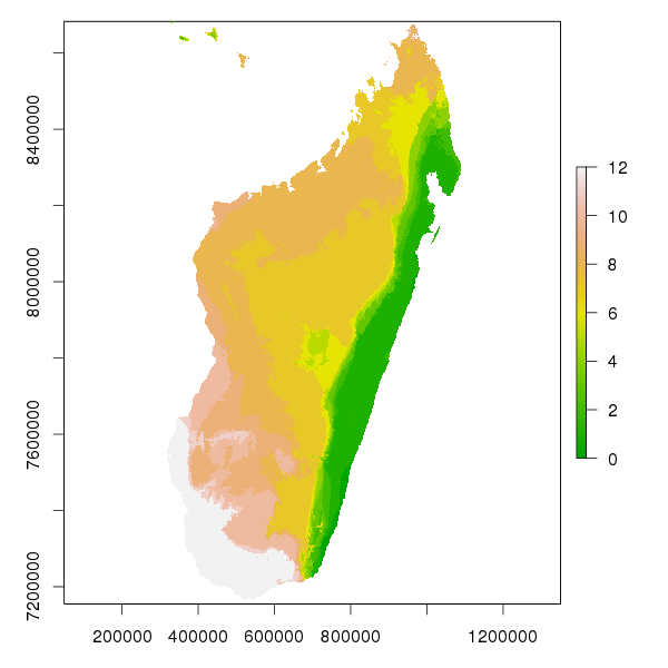
Current number of dry months.